 Dear Dany Tarigan,
Hell's Gate is located near Boston Bar on Trans Canada Highway #1, about 250 km from Vancouver. When British Explorer Simon Fraser reached here in 1808 he called "awesome gorge", but at the same time was his "greatest challenge" because of the difficulty in passing through during his expedition. Here the mighty Fraser River has to pass a 35 m narrow gorge, and creates a very strong rapid that is too fast for salmon to go upstream to spawn. Fraser River is best known as the North America's greatest salmon stream. Five species of salmon run the Fraser to spawn: chinook, chum, coho,
 pink and sockeye. But with joint effort between USA and Canada, the "International Fishways" were constructed and opened in 1945. The salmon survival rates was much improved since then.
In 1971 the Hell's Gate Airtram was built for public transportation to the Fishways, as it was set for tourist destination. There are 2 trams in operation, and they both move at the same time, one from the top end and the other from the lower end, as both are connected to the same cable. It is open for public between April - October. Access to the Fishways is only by the
 Airtram. It takes about 3 minutes tram ride each way for a distance of 345 m, and a vertical drop of 160 m. These are the things you can do and see: fisheries exhibit, suspension bridge and observation decks, interpretive signage, Salmon House Restaurant, a fudge factory, a cafe, a souvenir shop, gold panning and watching the fishways and the rapids.
I have visited Hell's Gate a few times in the past. The last time I went there was in 2003. It took about 3 hours drive from Vancouver to get there, following Highway #1 past Hope going along the deep and treacherous Fraser Canyon. Highway #1 that traverses along the Canyon was built basically along the Gold Rush trail of 1860's from Fort Langley to Cache Creek. It was an engineering feat in road constructions, and necessitated building tunnels in 5 places because of the steep mountain cliffs. At Hell's Gate, half way down from the level of Highway #1 and the Fishway there are 2 railway tracks, one on the east side of the river belongs to the Canadian Nationals (CN), and one on the west side belongs to the Canadian Pacific Railways (CPR). Both tracks are also engineering feats in construction, because the railroads cling precariously to both sides of the steep cliffs of the Canyon. British Columbia joined the Confederation in 1871 with a promise of railroad being built to join with Eastern Canada within 10 years. But because of difficult terrain of Fraser Canyon, the last spike for the CPR line was driven in November 7, 1885, 4 years late. It was considered as one of the most remarkable engineering epic of Canadian achievement. CN railway tracks were completed much later in 1913.
Top photo: Observation Deck and the Airtram. Suspension Bridge on the background.
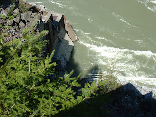
Middle: The "Fishways" on the left bank of the Fraser River, and the Rapid.
Bottom: Suspension Bridge looking across to the Observation Deck. It is used for emergency only, if airtram is malfunction for example. The CN tracks is just 10 m away. There is a steep trail going up to Highway #1 above.
